


Topography
The TN - BTS area is at 750 - 3,676 meters in height above sea level, its topographies vary from corrugated and sloping to hilly even mountainous with almost upright angles. In general, the TN-BTS area is hill land that consists of Tengger mountains group to the north and M. Jambangan group to the south. In eithe of the mountains group there are active volcanoes, id. est. M. Bromo ( 2,392 m. asl ) within Tengger mountains group and M. Semeru ( 3,676 m. asl ) within Jambangan mountains group. The activity of the two volcanoes affected very much topographies of the TN - BTS area.
Tengger mountains group is :
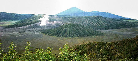
- a hill land ( > 2,000 m asl ) in which a caldera ( sand crater ) is 8 - 10 kms in diameter.
- The bottom of the crater is a large desert ( sand sea ) in which
- M . Bromo ( 2,392 m , asl ) M. Batok ( 2, 440 m,asl ) M. Widodaren ( 2,614 m asl )
- M. Watangan ( 2,601 m,asl ) and M. Kursi ( 2,581 m ,asl ) are located in the center.
The crater wall is surrounding steeply the sand sea in angles of 60 - 80 degrees and level range is between 200 - 600 meters.
- There are some mountains around the Tengger crater.
- They are M. Pananjakan (2,770 m, asl) M. Cemorolawang (2,227 m as)
- M. Lingker (2,278 m asl) , M. Pundak Lembu (2,635 m asl) M. Jantur ( 2,705 m asl)
- M. Ider - ider (2,527 m asl) and M. Mungal (2,480 m asl)
In Jambagan / Semeru mountains group there are
- M. lanang (2,313 m asl) M. Ayek -ayek (2,819 m asl) M. Pangonan Cilik (2,833m asl)
- M. Keduwung (2,334 m asl) M. Jambangan (3,020 m asl) M. Gentong (1,951m asl)
- M. Widodaren (2,000 m asl) M. Kepolo (3,035 m asl) M. Malang (2,401m asl)
- and M. Semeru (3,676 m asl) .
Semeru forest area has many rivers that are lava lines having maters from volcanic activities of Semeru. The matters are sand and volcanic stones / rocks. Viewing from south, Mount Semeru is like a perfect cone, with eastern slope more sloping than the weat At an elevation of 2.000 m asl. to the top, its slope is steep enough with a gradient more than 35. This area is called a production area, because volcanic matters for instance stone, gravel, sand, ash, hot cloud, and lava are vomited via a crater, than reduced in utmost area that makes this area is lack of vegetation.
At the elevation of 1000 to 2000 m asl. Its slope is not too step material volume of sediment is large enough. Since this part arteries and rivers sourced from Mount Semeru are recognizable, it is owing to the vegetation condition is beginning to dense and vary. At the elevation of 1,000 m asl down along the sloping that is more and more sloping and it is found that the more down an area, the more crowded its residences area with their fertile rice fields.
Next Prev