


Physical Conditions
Geology
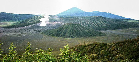
On the basis of geological map of Java and Madura in a scala ratio 1 : 500,000 from The Indonesian Directorate of Geology in 1963, that formation of the TN-BTS area is due to a volcanic activities from young quarter to old quarter.
Soil
Type of the soil is based on a map of Tanah Tinjau Propinsi Jawa Timur of 1966 is regosol and litosol. Matters of the kind of province are volcanic ash and fromintermediary to basic with strict permeability and the upper layer is very corrosive. its colors are from gray, brown, yellowish brown to white, with soil texture commonly from sand to ashy clay with an indenpendent structure or single fined and an indenpendent consistency or firm tough.
Climate
Slope, top and hill lands of a mountain surely have a different climate from a sea level one. An area tht is higher than a sea level has a lower temperature. The temperature of TN-BTS area ranges between 3 to 22 C. Its lowest temperature take place at dawn of the top of dry season ranging between 3 - 5 C. or even on some places often get lower to below 0 C ( minus). And its maximum temperature ranges between 20 - 22 C.
Based on a classification of climate types by Schmidt and Ferguson (1951), the climate of TN-BTS area is belong to climate type A including Southeast Semeru area, climate B with a Q value of 14.36% and an average rain 6604.4 mm/year (southern slope, peak, and eastern slope),type C including M. Argowulan area, Penanjakan,Keciri,Argosari Block, Ranu Kumbolo to Jambangan, and at Sand sea, Ngadas, Ranu Pane,Watu Pecah Block to Poncokusumo having climate type D with Q value = 43.86% with average rainfall 166mm/month. Air humidity around Sand sea is high enough with its maximum 90-97/e and is minimum 42-45% at an atmospheric pressure 1007-1015.7 mm Hg.
Hydrology
Like most of volcanic areas. TN-BTS area has a radical water order, so at dry season, surface water is hardly available or even completely extinct. It is due to all water that inundated soil surface during wet season disappeared quickly by penetrating lower layer of soil. The existing ground water is rain water that penetrate through spreading mountain stones, moving into stones layer below clay-stone layer which is watertight. Even though at a rainy season, a river within a volcanic stones area is full. But once the dry seasons comes, everything will be drying.
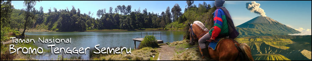
Water sources from TN-BTS are river and canals. They are documented as more than 50(fifty) rivers and 4(four) lakes within TN-BTS area The lakes are Ranu Darungan, Ranu Pane, Ranu Regulo, and Ranu kumbolo. It is shown that TN-BTS has a very important role in water order in regulation for its surrounding areas. The existence oh the springs of TN-BTS can accommodate a hygiene water requirement for communities in villages and can satisfy water requirement for farming and generating energy/ electricity power.
Prev