
Tourism Destinatons
About Ponorogo Regency
GEOGRAPHICAL
CONDITION
1. Situation, Boundary and Region
Wide.
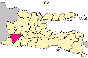
Ponorogo Regency is located between 111017' - 111o52 ' East
Longitudes and 7o49' - 8o20 ' South Latitude , with the
boundaries of administrative as follows
· North side: Madiun regency, Magetan and Nganjuk
· Eastside: Trenggalek regency and Tulungagung
· Side South: pacitan regency
· Westside: Pacitan regency and Wonogiri ( Central
Java ).
Ponorogo regency have regional wide about 1402,92 Km2.
2. Physiographic.
a. Height of Place.
Most region of plain in Ponorogo regency is between 100
- 500 m dpl. (58,79 %) and 500 - 1000 m dpl.( 25,83 % ).
Some places with height to 1000 m dpl is in Sooko, Ngebel
and Pulung district region.
b. Soil types.
Ponorogo regency have some soil types , most of them are
predominated by Litho sol (19,90 %), Litho sol (19,23 %)
, Grey Alluvial (17,15%) and Association of grey Alluvial
(11,49%), while the rest are deep brown Mediterranean soil
type, brown - grey Alluvial, Association of brown &
grumusel.
c. Geology Structure.
Based on region geology structure of Ponorogo regency had
divided into 8 kinds. The widest is Pliocene Sediment, Volcanic
Quarter and Alluvium, while other in area, which is smalls,
is Codas stones, young Volcanic Quarter, Andesite, Diorite
and Chalkstones.
3. Climatology.
Tightly climatology is bearing with the situation of height
place, therefore Ponorogo regency have tropical climate
and partly small subs tropical.

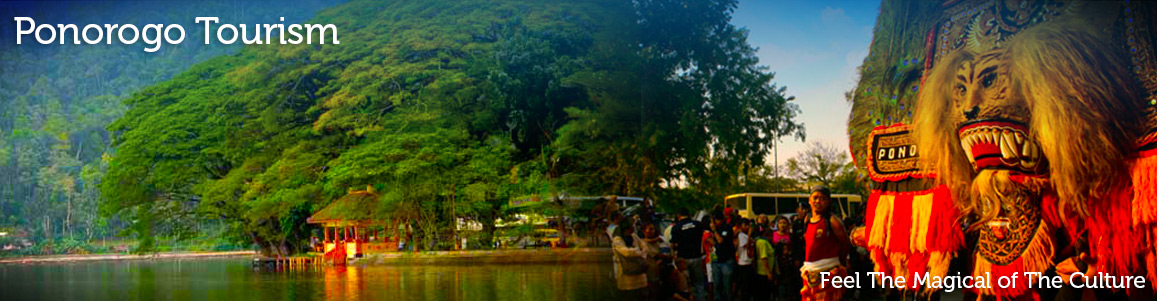
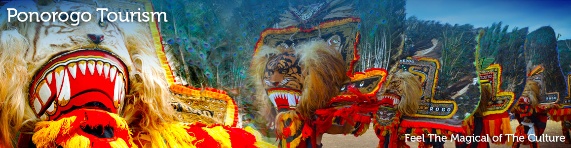
The Mystical Art Dance Of Reog Ponorogo
Reog Ponorogo Reog is a traditional dance that becomes the main identity from Ponorogo regency. By this traditional culture, Ponorogo is also famous as Reog city. This kind of traditional art dance and theatre has been popular in Indonesian even worldwide. Reog National Festival is being held every years along the anniversary of Ponorogo regency and followed by Grebeg Suro celebration. According to the background of the study, Reog is telling about the struggle of a prince who proposing his lovely pretty princess. This dance is staged about 25 –…
The Traditional Art Dance Of Reog Ponorogo
Reog Ponorogo Reog is a traditional dance that becomes the main identity from Ponorogo regency. By this traditional culture, Ponorogo is also famous as Reog city. This kind of traditional art dance and theater has been popular in Indonesian even worldwide. Reog National Festival is being held every years along the anniversary of Ponorogo regency and followed by Grebeg Suro celebration. According to the background of the study, Reog is telling about the struggle of a prince who proposing his lovely pretty princess. This dance is staged about 25 –…
Grebeg Suro Ponorogo
Grebeg Ponorogo Is the biggest culture event in Ponorogo regency that held on a certain occasion of welcomed Islam New Year or Saka New Year that often known as one suro date (one of Javanese month). This agenda entered East Java tourism calendar (Calendar of event). Grebeg Suro is the ritual culture incident and became the party site of Ponorogo people. Usually it begun a week before 1 Suro. It is the series of Grebeg Suro agenda is Reog National festival, various good activity sorts the race and the exhibition…
Reog Ponorogo
Reog Ponorogo Reog is a traditional dance that become the main identity for Ponorogo regency. Because of this, Ponorogo is also known as Reog city. This theatre has been known wide in Indonesian even foreign tourists. Reog National Festival is held every years along the anniversary of Ponorogo regency and Grebeg Suro celebration. Reog dance is also staged full moon nightly in paseban, Ponorogo Town Square. Reog told about the struggle for a prince who will propose to a lovely pretty princess . This dance is staged about 25 –…