|
Survival
Preperation Checklist
Compass
Tutorial
Navigation

|
HOW
TO USE COMPASS
Using the compass alone
This is a very easy lesson, and I would say, not sufficient for
those who would like to travel safely in unfamiliar terrain.
The first thing you need to learn, are the directions.
North, South, East and West. Look at the figure and learn how
they are.
North is the most important.
There are several kinds of compasses, one kind to attach to the
map, one kind to attach to your thumb. The thumb-compass is used
mostly by orienteers who just want to run fast, and this is the
kind of compass I normally use.
But not in this tutorial. I would recommend the third kind of
compass.
Let's take a look at it :
You
see this red and black arrow? We call it the compass needle. Well,
on some compasses it might be red and white for instance, but
the point is, the red part of it is always pointing towards the
earth's magnetic north pole. Got that? That's basically what you
need to know. It's as simple as that.
But
if you don't want to go north, but a different direction?
Hang on and I'll tell you.
You've got this turnable thing on your compass.
We call it the Compass housing. On the edge of the compass housing,
you will probably have a scale. From 0 to 360 or from 0 to 400.
Those are the degrees or the bearing. And you should have the
letters N, S, W and E for North, South, West and East.
If you want to go in a direction between two of these, you would
combine them. If you would like to go in a direction just between
North and West, you simply say: "I would like to go Northwest
".
Let's
use that as an example :
You want to go northwest. What you do, is that you find out where
on the compass housing northwest is. Then you turn the compass
housing so that northwest on the housing comes exactly there where
the large direction of travel-arrow meets the housing.
Hold the compass in your hand. And you'll have to hold it quite
flat, so that the compass needle can turn.
Then turn yourself, your hand, the entire compass, just make sure
the compass housing doesn't turn, and turn it until the compass
needle is aligned with the lines inside the compass housing.
Now, time to be careful!. It is extremely important that the red,
north part of the compass needle points at north in the compass
housing. If south points at north, you would walk off in the exact
opposite direction of what you want! And it's a very common mistake
among beginners. So always take a second look to make sure you
did it right!
A second problem might be local magnetic attractions.
If you are carrying something of iron or something like that,
it might disturb the arrow. Even a staple in your map might be
a problem. Make sure there is nothing of the sort around. There
is a possibility for magnetic attractions in the soil as well,
"magnetic deviation", but they are rarely seen. Might
occur if you're in a mining district.
When
you are sure you've got it right, walk off in the direction the
direction of travel-arrow is pointing. To avoid getting off the
course, make sure to look at the compass quite frequently, say
every hundred meters at least.
But you shouldn't stare down on the compass. Once you have the
direction, aim on some point in the distance, and go there.
But this gets more important when you use a map.
There
is something you should look for to avoid
going in the opposite direction : The Sun. At noon, the sun is
roughly in South (or in the north on the southern hemisphere),
so if you are heading north and have the sun in your face, it
should ring a bell.
When
do you need this technique?
If you are out there without a map, and you don't know where you
are, but you know that there is a road, trail, stream, river or
something long and big you can't miss if you go in the right direction.
And you know in what direction you must go to get there, at least
approximately what direction.
Then all you need to do, is to turn the compass housing, so that
the direction you want to go in, is where the direction of travel-arrow
meets the housing. And follow the above steps.
But why isn't this sufficient? It is not very accurate. You are
going in the right direction, and you won't go around in circles,
but you're very lucky if you hit a small spot this way. And that's
why I'm not talking about declination here. And because that is
something connected with the use of maps. But if you have a mental
image of the map and know what it is, do think about it. But I
think you won't be able to be so accurate so the declination won't
make a difference.
If
you are taking a long hike in unfamiliar terrain, you should always
carry a good map that covers the terrain. Especially if you are
leaving the trail. It is in this interaction between the map and
a compass, that the compass becomes really valuable.
Compass
types
Good
compasses have a fluid-filled housing; the fluid dampens the motion
of the needle, so that you can use the compass without holding
it perfectly still. Avoid inexpensive compasses that do not have
fluid-filled housings.
The compass needle is painted in two colors. Assuming that the
compass is held flat, the red end points to north, and the white
end to south.
An interesting detail is that there are northern- and southern-hemisphere
compasses. This has to do with the fact that the magnetic field
lines, to which a compass needle aligns, point into the earth
at the north and south magnetic poles.
In the northern hemisphere the north end of the needle is pulled
downwards, and the south end is counterweighted to balance the
needle. When you use a northern hemisphere compass in, say, Australia,
the south end of the magnet is pulled downwards by the magnetic
field, and is also heavier than the north end - resulting in a
needle that catches and drags on the bottom of the compass housing
when the compass is held horizontal.
A good compass will last a long time. However, some things can
go wrong with a compass: the plastic components can break, or
the housing can develop a leak. Over time, the fluid within the
housing may turn an opaque blue-green. And, very rarely, the magnetization
of the compass needle may reverse, so that the south end now points
to north.
There
are two main types of orienteering compasses:
The
baseplate or protractor compass
This type of compass was invented by the Kjellstrom brothers during
the World War II era and consists of a rectangular baseplate,
which is marked with a red arrow pointing along the long axis,
and a rotating compass housing marked in degrees (360 degrees
for the full circle in most of the world, but 400 on some European
compasses).
Marked on the floor of the rotating compass housing are an arrow
and a set of lines parallel to that arrow. Additional features
may include a lanyard for attaching the compass to the wrist,
scale bars for measuring map distances along one or more edges
of the baseplate, a magnifying glass for reading fine map detail,
and templates of a circle and triangle for marking orienteering
courses on the map
The
thumb compass
In
the mid 1980s, a top Swedish orienteer developed an alternative
to the baseplate compass by reshaping the baseplate and adding
a strap for attaching the compass to his thumb.
This compass is then placed on the thumb of the left hand, which
holds it on the map. The advantage of this system is that the
map and compass are always read as a unit, the map is aligned
more easily and quickly, plus one hand is left free; the disadvantage
is that running very accurately on a bearing is more difficult.
Personal preference usually determines the type of compass that
is used; world championships have been won using both types.
Using either type of compass,
there are two basic skills an orienteer needs:
orienting
the map
taking a bearing.
Using
a compass for orienting the map
This is a simple skill, and is probably the most important use
of the compass:
Hold your map horizontally.
Place the compass flat on the map.
Rotate the map until the "north lines" on the map (a
series of evenly spaced parallel lines drawn across the map, all
pointing to magnetic north) are aligned with the compass needle.
The map should now be oriented to the terrain. This makes it much
easier to read, just as text is easier to read right side up than
upside down.
Taking
a bearing
Every direction can be expressed as an angle with respect to north.
In the military and the boy scouts, this is called an "azimuth",
and bearings are expressed as a number of degrees. Orienteers
take the easy way out, just setting the angle on their compass
and keeping the needle aligned, which in turn keeps them going
in the right direction. A simple set of step-by-step instructions
for setting a bearing on a baseplate compass are:
place the compass on the map so that the direction of travel arrow
is lined up with the way you want to go
turn the compass housing so that the arrows engraved in its plastic
base are parallel to the north arrows drawn on the map (make sure
the arrowhead points north and not south)
take the compass off the map and hold it in front of you so that
the direction of travel arrow points directly ahead of you
rotate your body until the compass needle is aligned with the
arrow on the base of the compass housing
pick out a prominent object ahead of you along the direction of
travel, go to it, and repeat the process (this way you can detour
around obstructions but still stay on your bearing)
How
important is the compass?
The
most important navigational aid used in orienteering is the human
brain. One other navigational device is in allowed and in general
use: the compass. Compasses are useful for taking bearings and
for orienting the map so that it is aligned with the terrain -
but it is possible, in most areas, to complete a course quite
easily and efficiently without a compass (an exception: it would
be difficult to navigate flat areas poor in prominent features
without a compass).
The compass is the only legal navigational aid that can be used
in orienteering. Altimeters are specifically prohibited and GPS
units are implicitly prohibited by the rules. It has been stated
that GPS units could be very useful and helpful aids, but when
the question of how an everyday orienteer would use a GPS unit
to defeat the reigning US champion in a race was raised, the only
valid reply was: "I would wait at the first control for him,
use the GPS unit to knock him out, and then proceed on to victory".
Technology, however powerful, is no match for basic navigational
ability - even in the hands of a good orienteer who is also a
technological wizard.
Beginning
orienteers should learn basic compass skills and work on mastering
map reading.
|
| |
Using
the compass in interaction with a map
This is the important lesson, and you should learn it well.
It's when you use both compass and map the compass is really good,
and you will be able to navigate safely and accurately in terrain
you've never been before without following trails. But it'll take
some training and experience, though. I am not covering map reading
here, guess you would have to consult other sources for that, but
the lesson will be useful if you have a sense of what a map says.
Here
is our compass again:
The principles are much the same as in lesson 1 but this time,
you are using the map to tell you which way is correct instead
of your intuition.
Take
a map. In our first example, we look at a map made for orienteering,
and it is very detailed. Well, not really. We look at a fictitious
map I drew myself, but never mind.
To the point. You want to go from the trail-crossing at
A, to the rock at B. Of course, to use this method successfully,
you'll have to know you really are at A.
What you do, is that you put your compass on the map so that the
edge of the compass is at A. The edge you must be using, is the
edge that is parallel to the direction of travel arrow. And then,
put B somewhere along the same edge, like it is on the drawing.
Of course, you could use the direction arrow itself, or one of
the parallel lines, but usually, it's more convenient to use the
edge. At this point, some instructors say that you should use
a pencil and draw a line along your course. I would recommend
against it.
First, it takes a lot of time, but offers no enhancement in accuracy
of the method.
Second, if you have wet weather, it may destroy your map, or if
it is windy, you may loose it. You should keep your map (preferably
in a sealed) transparent plastic bag, and if it is windy, tied
up, so it can't blow away. But most important is that any drawings
may hide important details on the map.
Time to be careful again! The edge of the compass, or rather
the direction arrow, must point from A to B!
And again, if you do t his wrong, you'll walk off in the exact
opposite direction of what you want. So take a second look. Beginners
often make this mistake as well.
Keep the compass steady on the map. What you are going
to do next is that you are going to align the orienting lines
and the orienting arrow with the meridian lines of the map.
The lines on the map going north, that is. While you have the
edge of the compass carefully aligned from A to B, turn the compass
housing so that the orienting lines in the compass housing are
aligned with the meridian lines on the map.
During this process, you don't mind what happens to the compass
needle.
There are a number of serious mistakes that can be made here.
Let's take the problem with going in the opposite direction first.
Be absolutely certain that you know where north is on the map,
and be sure that the orienting arrow is pointing towards the north
on the map. Normally, north will be up on the map. The possible
mistake is to let the orienting arrow point towards the south
on the map.
And then, keep an eye on the the edge of the compass. If
the edge isn't going along the line from A to B when you have
finished turning the compass housing, you will have an error in
your direction, and it can take you off your course.
When
you are sure you have the compass housing right, you may take
the compass away from the map. And now, you can in fact read the
bearing off the housing, from where the housing meets the direction
arrow.
Be sure that the housing doesn't turn, before you reach your target
B!
The final step is similiar to what you did in lesson 1.
Hold the compass in your hand. And now you'll have to hold it
quite flat, so that the compass needle can turn. Then turn yourself,
your hand, the entire compass, just make sure the compass housing
doesn't turn, and turn it until the compass needle is aligned
with the lines inside the compass housing.
The mistake is again to let the compass needle point towards the
south. The red part of the compass needle must point at north
in the compass housing, or you'll go in the opposite direction.
It's
time to walk off. But to do that with optimal accuracy, you'll
have to do that in a special way as well.
Hold the compass in your hand, with the needle well aligned with
the orienting arrow. Then aim, as careful as you can, in the direction
the direction of travel-arrow is pointing. Fix your eye on some
special feature in the terrain as far as you can see in the direction.
Then go there. Be sure as you go that the compass housing doesn't
turn.
If you're in a dense forest, you might need to aim several times.
Hopefully, you will reach your target B when you do this.
Unfortunately,
sometimes, for some quite often, it is even more complicated.
There is something called magnetic declination. And then, for
hiking, you wouldn't use orienteering maps.
Finding
the directions without a compass
You are lost. I mean really lost. Standing in the middle of nowhere,
and you have no idea where to go. If you are really in trouble,
remember two things first of all: stay calm, think rationally,
and you can survive a long time without food. What you need is
to drink.
Further thoughts about extreme survival skills is beyond the scope
of this page, seek advice elsewhere beyond this introduction.
This page deals with the situation of finding your way, without
the aid of a compass.
What you have, is the sun, the stars, and the nature around you.
This
page is mainly about the northern hemisphere of the earth, actually
north of 23.5 °, because I have never been to the southern
hemisphere myself (would like to go there of course!). The methods
described do of course apply to the southern hemisphere as well,
but in some places there may be a need to swap north and south
to get it right. I hope you are able to figure it out.
For
a start, it may be a good idea to climb a hill, and get a
good look around. Try to see traces of human activity. If you
see nothing, you should try to figure out in what direction would
be the best to travel. If you haven't got a map, try to draw one
if you can of the terrain in front of you, and try to mark off
where north is, using the methods below. If you have got a map,
try to determine where you are. Remember, you don't want to climb
more hills than you have to. Also you should carefully consider
not to climb if you are very tired. In that case you should consider
staying where you are. Consult other sources for information on
how to make it easy for rescuers.
Let
us start with the most accurate method.
This method requires that you have a pretty clear sky, though,
and takes a lot of time. One of the advantages is that you don't
need any equipment. You would need a straight pole about 1 meter
(or a yard) long, two small sticks or rocks, another stick (or
rock) that needs to be a little sharp, and something that can
act as a string.
In
the morning, at least before noon, the trick starts.
Stick the long pole in the ground, upright. The ground around
the pole needs to be horizontal. Now, you can place one of the
little sticks in the ground exactly where the shadow of the pole
ends, like on the figure. Then tie the string to the base of the
pole, and tie the little, sharp stick, to the other end, so that
when the string is stretched it reaches exactly the little stick
standing there in the soil. Then, scratch half a circle in the
soil with your sharp little stick, and wait... Wait. Wait until
the evening. During the day, the shadow will get shorter and shorter,
until noon, when it gets longer again.
At noon, when the shadow is at its shortest,
you may want to mark the point. The shadow is now pointing north
(if you are north of 23.5 ° north).
It is however not very easy to see exactly when this is, but it
is useful anyway. Finally, the shadow reaches your circle again,
and when it does, place your other little stick at the spot where
the shadow ends.
If you haven't got a string, you could use a pole that has the
right length, or try to come up with some other improvised solution.
Just make sure what you draw is a circle.
Now, the line from the first stick to the second is west-east,
like on the figure. Actually, you may want to mark points regurlarly,
because any two points that have exactly the same distance from
the base of the pole will give the West-East line. If it is partly
cloudy, this may be a good idea.
There
is a short, fast version of this one as well.
This is only approximate, though, and the further away from the
equator you get, the more inaccurate is it. You don't need the
sharp stick and the string. Just wait 20 minutes between placing
each of the sticks, and the line between the two sticks will be
approximately west-east, like on the figure. Often, you wouldn't
need anything more accurate.
At night, you can navigate after the stars.
You should, however, be careful with walking, it is easy to stumble
and fall and get injured, and also easy to lose sight of the stars
as you go, and you might start going around in circles. Often
it will also be more physically and mentally demanding. In the
northern hemisphere, there is a star that is almost exactly in
the north at all times, the Polaris. It is pretty easy to find,
if you know the "Big Dipper". (Everybody knows the Big
Dipper (or the Plough)?) Take the two stars at the end of the
"Big Dipper", and make an imaginary line "upwards",
and extend it five times the distance between the two stars. There
you have it - Polaris. That way is always north. The figure is
courtesy of Kathy Miles. Used with permission.
In
the southern hemisphere, you would have to find the Southern
Cross. Because I haven't been south of the equator, I can't help
you find it, make someone tell you where it is right now, if you
don't know it already.
That way is south.
If you have an analog wrist watch, you can use the time to
find north.
Hold your watch up in front of you, and let the short hand, red
on the figure,
that indicates hours point at the sun. While holding it like this,
cut the angle between the red arrow and 12 o'clock in two, (noonwards
if the time is before 6am or after 6pm), that way is south. (The
reason you need to cut it in two, is because the clock takes two
rotations in while the sun takes one around the earth, it is of
course the other way around, but never mind.)
Many
people wear digital watches these days. If you do, draw an analog
watch face on a piece of paper, and then mark the hour hand on
using the digital watch. The rest of the method is identical.
This
method can be used even when it is pretty foggy. Although you
may not be able to see the sun, it may still cast a shadow. If
you take up a straw or a tiny stick, and you may see a shadow.
You just have to remember that the shadow points the opposite
way from the sun, but the rest of it is quite similar as above.
Want to make your own compass?
Sure. You need a needle and a glass of water. A needle can in
fact float on the water, or that is, on the surface tension forces
if put carefully on the surface. Just put it carefully down on
the surface of the water. This demands a lot of patience though.
There are three tricks that makes it go easier.
One : Put the needle on a piece of paper. If the paper
floats too, there is no problem, and if the paper sinks, it'll
probably leave the needle.
If you put some grease on the needle that isn't water-based, it'll
go easier, or if you put it carefully down with a fork or something.
Once it has got there, it stays there pretty good.
If
the needle is magnetic, it will act as a normal compass and be
very accurate. A problem is though, that you don't know north
from south.
All you know is that it lays north-south. You would have to use
one of the other techniques to find out, or make a good guess.
The
greatest problem with this is: Not many needles are made of magnetic
materials these days.... You can't just use any needle. You may
just have to look around to see what you can find, if you want
to make a yourself a compass.
What
if there is no shadow?
Then, there are a few methods based on natural signs.
I will deal with the ones I have checked myself.
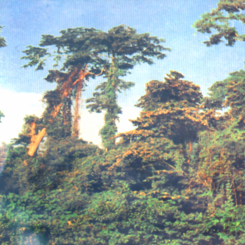
It is very much about trees.
First of all, there will be fewer branches to the north. This
is usually easiest to see if you look up along the trunk of the
tree. The north face of the tree would be more humid than the
south face, which is something most species of lichen likes, and
consequently, there will be more of it on the north face. On the
image above, you can also see that ants likes to build their nests
on the south side of the tree.
It
is also worthwhile to look at how snow melts. In the spring in
the mountains, snow will melt faster on the south face of rocks,
or in south faced slopes. Also, vegetation and undergrowth will
typically be thicker on the South facing slopes, and also fruits
ripen earlier on the South facing slopes.
These
methods are not very reliable, I am afraid.
Winds may alter the average conditions significantly, and cause
deviations.
If you use natural signs, you should use as many signs as you
can before you draw a conclusion.
|