Tourism Destinatons
About Pamekasan Regency
GENERAL DESCRIPTION ABOUT PAMEKASAN
Pamekasan regency lies between Sampang regency (southward)
and Sumenep regency (eastward). Whereas, north side is
restricted by the Java sea and south side by the Madura
strait. Pamekasan is the Madura’s capital is just
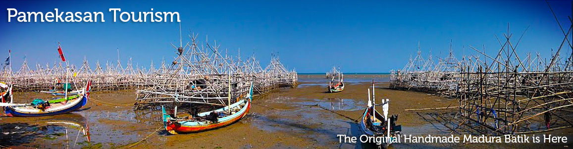
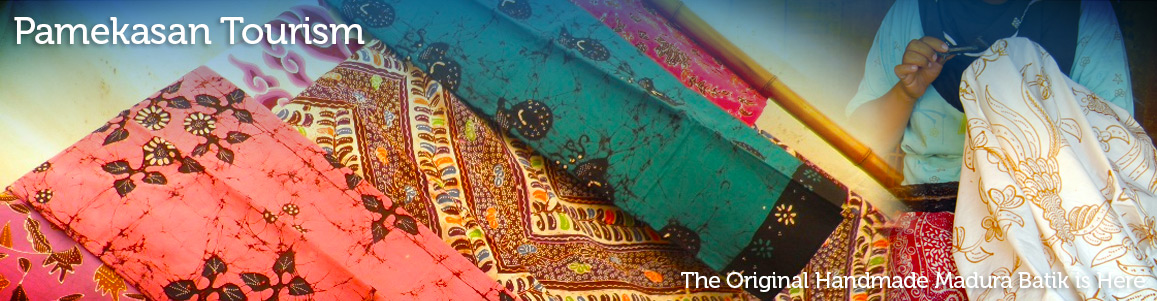
33 km east of Sampang. Handmade Batik from thisregency
has its own design among Madura’s batik. Take a
visit to Proppo village to see batik making. Nature resource
is located less than 600 meter from main road Sampang-Pamekasan.
Whereas, the natural resources potentials economically
are very promising for us to be developed among other
things: Plantation, Agriculture, Animals Husbandry, Sea
and Fishery, Industry, Mining, Culture and Tourism Potentials.
GEOGRAPHICALLY
The boundaries of Pamekasan area, are:
- West side: Second Level Regency of Sampang
- East side: Second Level Regency of Sumenep
- Northern and Southern: Java Sea and Madura Straits.
- Area of land: 79,230 ha
- Area of coast: 18,000 ha
Sumenep regency is lies between 113° 20° to 113°
East Longitude and 6° 20° South Latitude.
TOPOGRAPHY
Pamekasan Regency lies 0 to 340 m above sea level with
an average height of 0% to 8% cover the southern area
and the northern area is relatively flat. Undulating and
hummocky area lies on 50 to 340 m above sea level with
declivity 30% to 50% with detail as follows:
- Flat: 33.74%
- Undulating: 40.03%
- Hilly (Hummocky): 22.23%
CLIMATE
Average rainfall in Pamekasan regency is 1,574-mm/ year
92 rainy days in 1 year. So it has 3 months wet period
and 5 to 9 months dry period. The average temperature
is 28° C to 30° C with humidity of 80%.
THE LAND TYPE
The Second Level Regency of Pamekasan has more or less
15% paddy fields (sawah) and 85% of dry land.
Soil layer in this area consists of:
- Mediteranian: 60%
- Alluvial: 15%
- Regusol: 10%
- Grumosol: 5%
Based on the land type, Pamekasan regency consist of:
a. Official Standard Rice Field
b. Rain-Irrigated Rice Field: 59.49 Km2
c. Dry (not Irrigated) field: 466.92 Km2
d. Housing: 98.70 Km2
e. Plantation: 68.82 Km2
f. Forest Area: 8.62 Km2
g. Fish Pond: 2.03 Km2
h. Other: 19.56 Km2
Total: 792.30 Km2
DEMOGRAPHY
The total Population Pamekasan regency in 1994 is 634,197
consisting of:
- Male: 304.264
- Female: 329.933
- Population density: 800.45 per Km2
- Population growth: 1.54%
Total population based on occupation as follows:
- Agriculture: 57.85%
- Industry: 10.21%
- Construction: 3.94%
- Trading: 14.64%
- Transportation and Communication: 3.45%
- Public Service: 6.20%
- Other: 3.71%
ADMINISTRATION AREA
Administratively, Second Level Regency of Pamekasan consist
of:
- 4 Political district administration by Regent Assistants.
- 13 Sub district
- 11 Political District administration by Village Chief
(lurah) and 178 Villages
Then, the detail of political district administration
by Regent Assistants and sub districts are as follows:
a. Political district administered by Regent Assistant
in Pamekasan Sub district i.e:
- Pamekasan Sub district
- Proppo Subdistrict
- Tlanakan Subdistrict
b. Political district administered by Regent Assistants
in Galis covers 3 Sub district i.e:
- Galis Sub district
- Pademawu Sub district
- Larangan Sub district
c. Political district administered by Regent Assistant
in Pegantenan covers 4 Sub district i.e.:
- Pegantenan Sub district
- Palengaan Sub district
- Pakong Sub district
- Kadur Sub district
d. Political district administration by Regent Assistants
in Waru covers 3 Sub district i.e.:
- Waru Sub district
- Batumarmar Sub district
- Pasean Sub district
POPULATION
The population in 1994 shows that the population in East
Java Increase 1.54% from the mid 199. In the mid 19...
In the mid 19...
The total population of the Pamekasan Regency is 634,127
with number of men 304,264 and number of women 329,933
while, total of workforce ................

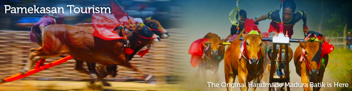
Madura Annual Bull Race
Karapan Sapi Karapan Sapi, is Madura annual traditional event, it is such a bull racing tournament. It usually being held at week end within August to September, or ideally before or after the fasting month. Date back to the early begin, Karapan Sapi was exist before 15 Century. The championship is starting from the district level to the regency level and forwarded to the level Residence. Last, the final will be held on September or October in the city of Pamekasan to compete for President Cup. Karapan Sapi is such…
Madura, Strong Like The Bull
Madura Madura is one of Indonesian Island, which is located on northeastern coast of Java Island. The indigenous are about ethnically Madurese, with particular language of Madurese. Politically, Madura, over the centuries had become subordinate to regional authority based in Java. Around the year 900-1500, the island is under the influence of the east Javanese Hindu kingdom like Kediri, Singhasari, and Majapahit. Madura ethnic, like Tionghoa ethnic is such a large ethnic which spread all over Indonesia area. Madura is one of the poorest area. Unlike other area in Indonesia,…
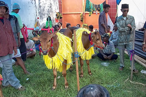
Madura Annual’s Ceremony : Bull Race
The Background Of Bull Racing Bullrace is one of Madura’s culture, which become the special characteristis of Madura Island. The beginning of the bullrace originated from the fact that Madura is not so fertile that is not good for agriculture, instead the Madurese cath fish and breed cows and bulls which are also used for farming especially to plough the fields where paddies or second crop plants are grown. A man named Syeh Ahmad Baidawi who firstly introduced the weay of working the soil with using bamboo sled pulled by…